Characterisation

Geagrofía has characterised the socioeconomic and environmental variables of territories to enable the design of research and development projects.

Click on the links below for examples and more information.

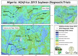
N2Africa action area characterisation

Ecuador has one of the highest rates of chronic infant undernutrition in Latin America. We used statistical and spatial analyses to examine the distribution of food consumption and food poverty and to test and generate hypotheses of food poverty estimates at the district level. We showed that the food poor are concentrated in certain locations with a significant cluster identified in the central Andean region. Geographically weighted regression showed that the processes underlying food poverty in Ecuador were also spatially variable.

CIALCA mandate area characterisation


Site selection for the Lake Kivu Pilot learning Site of the Sub-Saharan Africa Challenge Programme

Selecting sites was an essential step in enabling the assessment of the impact of Integrated Agricultural Research for Development (IAR4D) in the Lake Kivu Pilot Learning Site. This research identified distinct administrative territories in which to establish innovation platforms and to monitor counterfactual sites. Candidate sites were stratified according to the national political context, followed by good and poor accessibility to markets and finally according to security considerations and agro-ecology. Randomisation was carried out at all levels, although the need for paired counterfactual sites required the diagnosis of conditioning factors at the site level. Potential sites were characterised in terms of existing or recent agricultural research initiatives, as well as local factors that would have a direct effect on the success of interventions seeking to improve productivity, ameliorate the degradation of natural resources and enhance incomes through better links to markets.

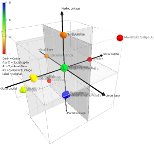
African Farmer groups


Back to Services